Odisha, a coastal state in eastern India, is bracing for heavy rainfall as a low-pressure system develops over the Bay of Bengal. The India Meteorological Department (IMD) has issued warnings for various districts, forecasting widespread rains, including some areas that could experience very heavy rainfall over the next few days. In this article, we’ll break down what this weather pattern means for the region, what the people of Odisha can expect, and what safety precautions should be taken.

The low-pressure system forming over the Bay of Bengal is a key weather feature that often signals the onset of significant rainfall in coastal regions like Odisha. The system is expected to move northwestwards and may intensify into a depression. The resulting heavy rains will likely lead to localized flooding, landslides, and transportation disruptions. Authorities are closely monitoring the situation and have issued red, orange, and yellow warnings for different districts.
Rainfall Likely in Odisha with Low Pressure
| Topic | Details |
|---|---|
| Weather Event | Low-pressure system developing over Bay of Bengal |
| Predicted Impact | Heavy to very heavy rainfall across Odisha |
| IMD Warning Levels | Red, Orange, and Yellow warnings for affected areas |
| Heavy Rainfall Forecast | Up to 20 cm in some districts, including Mayurbhanj, Keonjhar, Sundargarh |
| Safety Measures | Avoid unnecessary travel, stay updated with local warnings |
| Source | IMD, Hindustan Times |
The low-pressure system over the Bay of Bengal is a serious weather event for Odisha, bringing with it the likelihood of significant rainfall and potential flooding. It’s essential for residents to stay prepared, keep track of weather updates, and take the necessary precautions to protect themselves and their communities. By following safety advice and staying informed, the people of Odisha can better navigate the challenges posed by this weather event.
What is Low Pressure and How Does it Affect Odisha?
In simple terms, a low-pressure system occurs when the air pressure in a specific area is lower than the surrounding regions. These systems are often associated with stormy weather and rainfall because the low pressure allows air to rise and form clouds, which can lead to precipitation. In the case of Odisha, this low-pressure area is forming over the Bay of Bengal, and it’s expected to bring significant rainfall in the coming days.
This phenomenon is not unusual for Odisha, as the state is frequently affected by such systems, particularly during the monsoon season. In fact, Odisha’s coastal location makes it highly susceptible to weather patterns originating in the Bay of Bengal, such as tropical cyclones and low-pressure areas.
Why Is This Important for Odisha?
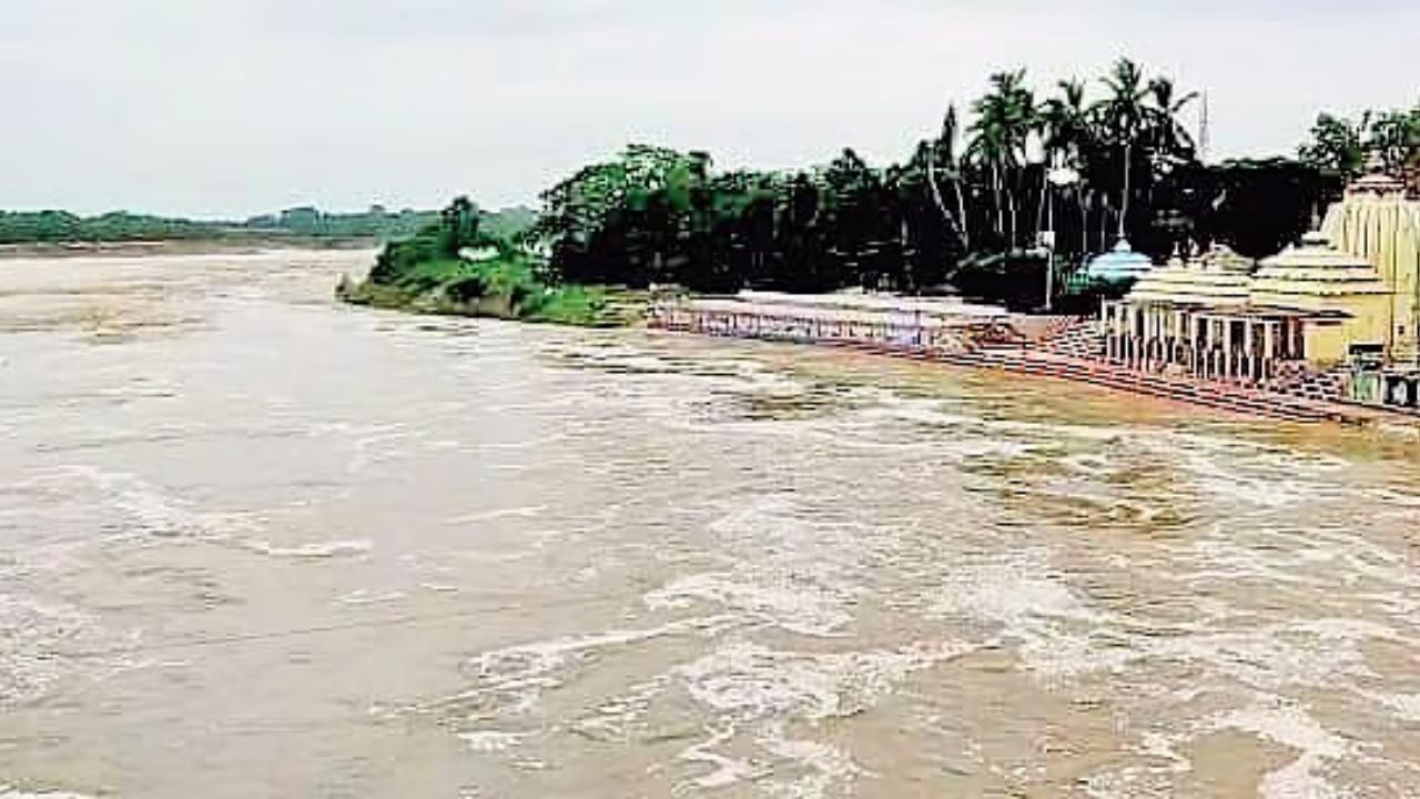
Odisha’s geographical location, nestled between the coast and the inland plains, makes it vulnerable to heavy rainfall, especially during the monsoon months. The state’s economy, heavily reliant on agriculture, can be severely affected by both floods and droughts. While rainfall is essential for crop growth, excessive rainfall can lead to flooding, damaging crops and displacing people.
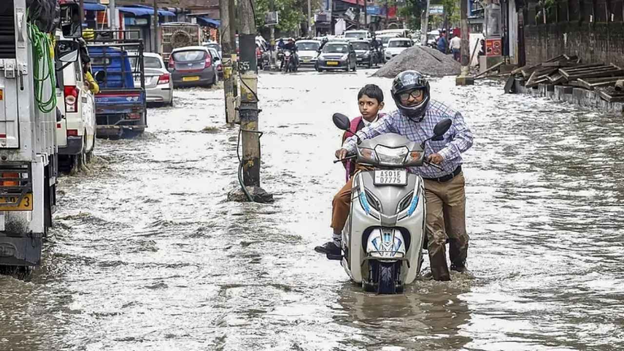
The weather events tied to these low-pressure systems can cause road disruptions, landslides, and even flash floods, particularly in the hilly areas of the state. It’s essential for the public to be aware of the developing situation and take appropriate precautions.
What Areas Will Be Affected?
The IMD has issued a variety of warnings for different parts of Odisha based on the severity of the rainfall expected. Here’s what you can expect:
- Red Warning: The districts of Mayurbhanj, Keonjhar, and Sundargarh are likely to experience extremely heavy rainfall (more than 20 cm). These areas should be prepared for the possibility of flash floods and significant disruptions to daily life.
- Orange Warning: Areas like Dhenkanal, Jajpur, Kendrapara, Bhadrak, and Balasore are expected to receive very heavy rainfall (12–20 cm). These regions may also face localized flooding, particularly in urban areas and low-lying zones.
- Yellow Warning: Other districts across Odisha could receive heavy rainfall (7–11 cm). Although the rainfall in these areas may not be as intense, residents should still be cautious and stay updated.
The IMD’s warnings are aimed at helping local authorities prepare for the worst and to keep the general public informed so they can make the necessary arrangements to protect themselves and their families.

Practical Advice for Residents
Living through heavy rainfalls and possible flooding can be overwhelming. Here are some practical steps that residents in affected areas can take:
1. Stay Informed
- Make sure to stay tuned to IMD updates, local news channels, or official government sources for real-time weather reports and safety instructions.
- Download weather apps or follow social media channels for immediate alerts about weather changes.
2. Prepare for Flooding
- If you live in a flood-prone area, move valuables and essential items to higher ground.
- Sandbags can help divert water from entering homes in vulnerable spots.
- Be sure to have an emergency kit on hand, which should include things like water, food, flashlights, and medications.
3. Driving Precautions
- Avoid unnecessary travel, especially in the event of flooding or heavy rain.
- Stay off roads that are flooded, and if you encounter flooded streets, turn around instead of driving through them. Flooded roads can be deceiving and dangerous.
4. Stay Indoors During Storms
- If a thunderstorm is imminent, avoid open fields or standing under trees, as lightning can strike in such conditions.
- Keep doors and windows closed, and avoid using electrical appliances during thunderstorms.
5. Emergency Numbers
- Make sure you have emergency numbers for local disaster management authorities, hospitals, and the police handy.
6. Help Neighbors
- Look out for elderly neighbors or those with young children who might need assistance during storms. They might not have the resources or strength to prepare or evacuate.
What Can You Expect in the Coming Days?
As the low-pressure system moves across the Bay of Bengal, residents can expect continued rainfall and a cooler climate. While this provides relief from the heat, it also brings challenges in terms of flooding, disruptions to daily life, and potential damage to infrastructure.
The IMD is predicting that by July 24, the system may intensify into a depression, which could cause further impacts. By then, the intensity of the rainfall is expected to peak, with periods of heavy showers and thunderstorms.
Odisha Prepares for Nature’s Wrath: Monsoon Rainfall to Intensify from July 21
Rourkela Struggles with Severe Waterlogging Following Heavy Downpour
Odisha Braces for Heavy Rain: IMD Issues Yellow Alert for Six Districts Today
FAQs
1. What is the difference between a low-pressure area and a cyclone?
A low-pressure system is a weaker weather system that can bring heavy rain and thunderstorms. A cyclone is much stronger, bringing violent winds, heavy rain, and storm surges. Cyclones are a much more severe threat.
2. How do low-pressure systems form?
These systems form when warm air rises over the ocean, causing lower air pressure. This process creates clouds and precipitation, which can intensify into storms depending on other atmospheric factors.
3. What should I do if I live in a flood-prone area?
If you live in a flood-prone area, make sure your house is prepared with sandbags, backup power, and an evacuation plan. Avoid driving in flooded conditions and stay indoors when rain is heavy.
4. How do I stay safe during a thunderstorm?
During a thunderstorm, avoid using electrical appliances, stay away from windows, and seek shelter in a safe, sturdy building. If outside, stay away from tall trees and open fields.
5. When will the rain stop in Odisha?
The heavy rains are expected to continue until July 24, with the possibility of tapering off as the low-pressure system weakens or moves away.