When it comes to weather warnings, folks in Odisha, India, know the drill: keep an eye on the skies, and don’t underestimate the power of heavy rain. Right now, the India Meteorological Department (IMD) has sounded the alarm—flood-prone districts in Odisha are expected to face sustained rainfall, thunderstorms, and possible flooding until August 19, 2025.

For people living in the state—whether in the bustling capital of Bhubaneswar or small villages tucked into the hills—the message is clear: stay alert, stay safe, and prepare for potential waterlogging, road closures, and local disruptions.
Odisha’s Weather Alert
| Category | Details |
|---|---|
| Event | Odisha Weather Alert (August 16–19, 2025) |
| Issued By | India Meteorological Department (IMD) |
| Warning Levels | Yellow & Orange alerts across 20+ districts |
| Weather Forecast | Heavy rainfall, thunderstorms, gusty winds (30–40 km/h) |
| Flood-Prone Districts | Koraput, Malkangiri, Rayagada, Nabarangpur, and surrounding areas |
| Risks | Flooding, waterlogging, landslides, crop damage, power disruption |
| Practical Advice | Avoid unnecessary travel, secure belongings, prepare emergency supplies |
| Timeframe | August 16–19, with lingering showers after |
| Official Source | IMD Official Website |
Odisha’s weather alert is a reminder of how powerful nature can be—and how crucial it is to prepare. With warnings in place until August 19, residents in flood-prone areas should treat this spell with seriousness, but not fear. By following official advisories, taking small but practical safety steps, and keeping community resilience alive, Odisha can weather this storm—literally.
What’s Going On in Odisha’s Skies?
Here’s the science bit—but don’t worry, we’ll keep it simple. The culprit is a low-pressure system sitting over the Odisha-Andhra Pradesh coastline. Think of it as a giant “vacuum” pulling in moist air from the Bay of Bengal. This sets up a perfect recipe for non-stop rain, stormy winds, and thunderstorms.
IMD reports suggest:
- 20+ districts under Yellow Warning (watch out but don’t panic).
- Southern and hilly districts under Orange Warning (get ready, it’s serious).
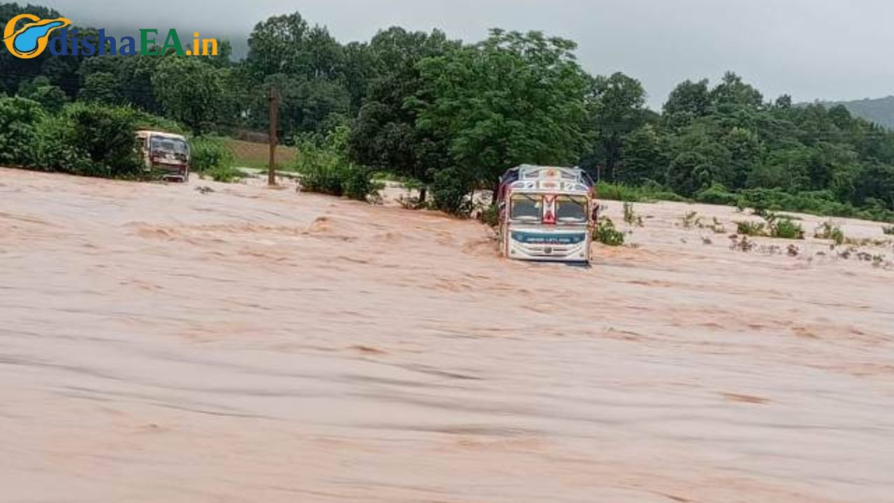
- Heavy rainfall is expected to hit areas like Koraput, Malkangiri, Rayagada, and Nabarangpur the hardest.
And here’s the kicker: continuous rain isn’t just an inconvenience—it raises real risks of flash floods, landslides, and waterlogging.

Why Flood-Prone Zones Need Extra Attention
Odisha is no stranger to floods. With its long coastline, river systems, and hilly terrain, the state often ends up being ground zero for extreme weather events. According to the National Disaster Management Authority (NDMA), more than 40% of Odisha’s landmass is flood-prone.
In 2022, severe monsoon rains displaced over 1.5 million people in Odisha. And with climate change intensifying monsoon patterns, heavy rain events like this one are becoming more frequent.
So, for people in low-lying neighborhoods, hilly villages, and riverbank settlements, this isn’t just about getting wet—it’s about livelihoods, safety, and survival.
Practical Steps to Stay Safe (For Families, Farmers & Professionals)
When the forecast spells trouble, here’s a straightforward plan—because let’s be real, not everyone has the luxury of waiting it out indoors.
1. For Families & Residents
- Stock up on essentials: drinking water, dry food, flashlights, and batteries.
- Keep important documents in waterproof bags.
- Avoid stepping into floodwater—it may carry electric shock risks or disease.
2. For Farmers
- Harvest crops early if possible; secure produce in safe storage.
- Move cattle to higher ground.
- Follow Krishi Vigyan Kendra advisories for district-level weather alerts.
3. For Commuters & Professionals
- Avoid unnecessary travel during heavy rain days (work from home if possible).
- Use official IMD alerts instead of relying on social media rumors.
- Businesses should back up digital files in case of power outages.
The Bigger Picture: Climate Change & Rising Flood Risk
This isn’t just about Odisha—it’s a global story. Across the U.S., we’ve seen the same playbook: from Hurricane Katrina’s floods in New Orleans to recent flash floods in California. Just like in America, local communities in Odisha are learning to adapt:
- Early-warning systems are stronger now.
- Disaster management authorities regularly run evacuation drills.
- Grassroots NGOs are helping families build flood-resilient housing.
But the truth? Without climate action, these “extreme rain spells” will only get worse. NASA’s climate research shows monsoons are intensifying due to warming oceans.
Local Voices: Life During Heavy Rains
Ask any Odia family, and they’ll tell you: rain isn’t just weather, it’s a season of stories. Kids splash in puddles, fishermen weigh risks at sea, and farmers pray for just enough rain—but not too much.
One farmer from Koraput put it this way: “When it rains like this, we think of God’s blessing and God’s test at the same time.”
It’s a perspective Americans in flood-hit states like Florida or Texas would recognize too—weather is more than science, it’s a lived experience.
What’s Next?
- August 16–17: Rain with thunderstorms (Yellow alert).
- August 17–18: Heavier rainfall in south Odisha (Orange alert).
- August 19: Lingering showers, then gradual easing.
That means folks have 72 hours of serious caution ahead. Local authorities are prepping for possible evacuations and rescue efforts, while power utilities brace for outages.
Khanduru Farmers Abandon Betel Cultivation as Government Support Falters
Govt Report Reveals Fivefold Rise in EMRS School Dropouts, Chhattisgarh and Odisha Hit Hardest
Odisha Fishermen Struggle as Trump’s Tariff Raise Hits Seafood Exports
FAQs on Odisha’s Weather Alert
Q1: What does a Yellow Warning mean?
It means “watch out.” Be cautious but don’t panic—rain and storms are likely.
Q2: What about Orange Warning?
That’s more serious: “be prepared.” It means heavy rain, flooding, or damage is possible in your area.
Q3: How long will this rain last?
Until August 19, 2025, with lingering showers afterward.
Q4: Which districts are at highest risk?
Southern and hilly areas: Koraput, Malkangiri, Rayagada, Nabarangpur.
Q5: Where can I find official updates?
Check the IMD Website or local government bulletins.