BHUBANESWAR, Odisha – The Mahanadi river system in the eastern Indian state of Odisha is under severe strain as massive volumes of water released from the Hirakud Dam, combined with incessant upstream rainfall, have caused the river to swell significantly. Officials confirmed that the water flow at the Mundali barrage near Cuttack surpassed 4.47 lakh cusecs on Wednesday, prompting authorities to issue high alerts for several downstream districts and prepare for a potential medium-level flood situation.

Mahanadi Swells in Odisha
| Key Fact | Detail / Statistic | Source / Context |
| Peak Water Flow | Over 447,000 cubic feet per second (cusecs) recorded at Mundali barrage. | Data from Odisha’s Water Resources Department. This is a critical monitoring point for the Mahanadi delta region. |
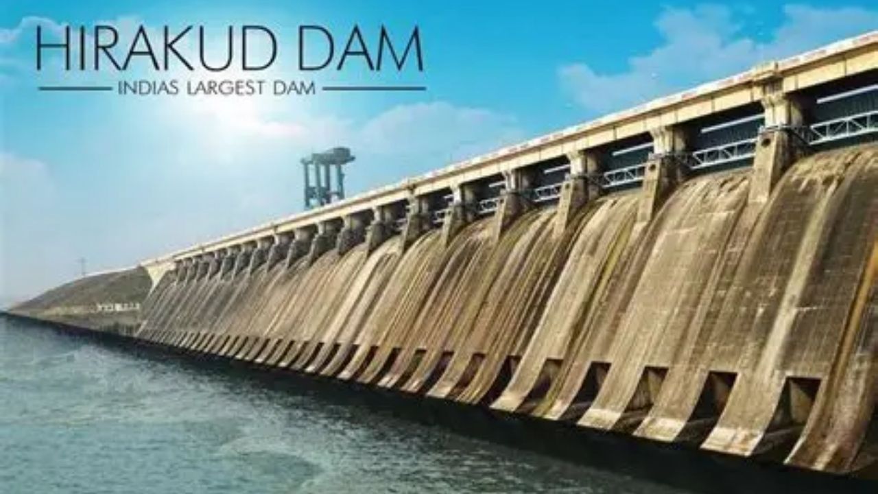
| Hirakud Dam Discharge | Officials have opened 26 of the dam’s 64 sluice gates to manage reservoir levels. | Statement from the Chief Engineer of the Hirakud Dam. The dam is crucial for both flood control and irrigation. |
| Districts on Alert | At least 10 districts, including Cuttack, Puri, Kendrapara, and Jagatsinghpur, are on high alert. | According to the office of the Special Relief Commissioner (SRC). |
| Cause of Swell | A combination of heavy rainfall in the upper catchment areas of Chhattisgarh and controlled discharge from Hirakud Dam. | Meteorological reports and official government briefings. |

A high-quality, recent news photograph showing the wide expanse of the Hirakud Dam. The image should clearly depict multiple sluice gates open and the powerful flow of water, emphasizing the scale of the operation. Photo credit from a reputable source like the Press Trust of India (PTI) or a major news agency should be included.
Authorities Manage Unprecedented Water Flow
State and district-level authorities are working around the clock to manage the heavy influx of water and mitigate its impact. The discharge from the Hirakud Dam is a carefully controlled measure designed to prevent a catastrophic failure of the reservoir, which is currently nearing its full capacity of 630 feet.
“We are continuously monitoring the water level at the dam and the inflow from the upper catchment areas,” said an official from Odisha’s Water Resources Department in a press briefing. “The release of water through the 26 gates is a calibrated effort to balance the reservoir’s safety with the potential impact on downstream areas.”
The flow of 4.47 lakh cusecs at the Mundali barrage is a significant benchmark that signals a heightened risk of flooding in the densely populated coastal plains. The administration has positioned response teams from the National Disaster Response Force (NDRF), Odisha Disaster Rapid Action Force (ODRAF), and local fire services in vulnerable low-lying areas.
Impact on Downstream Communities
The rising waters of the Mahanadi and its tributaries, such as the Devi, Daya, and Bhargavi, are already affecting life in the coastal districts. Reports from regional officers indicate that low-lying agricultural fields are beginning to see inundation, and road connectivity in some rural pockets has been disrupted.
Pradip Kumar Jena, the Special Relief Commissioner (SRC), has assured the public that the government is prepared for the contingency. “We anticipate a medium-level flood in the Mahanadi delta region,” Jena stated in a communication to the media. “District collectors have been instructed to take all precautionary measures, including the evacuation of people from vulnerable areas to designated cyclone and flood shelters. Ample provisions for dry food, clean drinking water, and medical supplies are being arranged.”
Officials are particularly concerned about the ‘gales’ or narrow breaches that can occur in river embankments under such high pressure, which could lead to flash flooding in riverside villages. Engineers and patrol teams are inspecting these embankments for any signs of weakness.
simple data visualization (line graph) that clearly communicates the core data driving the event. The X-axis would show the date, and the Y-axis would show the water level in feet. A separate line or bar chart element could show the corresponding outflow in cusecs to illustrate the cause-and-effect relationship. Source data should be credited to the Odisha Water Resources Department.
The Role of Hirakud Dam and Monsoon Patterns
The Hirakud Dam, one of the longest earthen dams in the world, is central to managing the monsoon season in Odisha. Completed in 1957, its primary purposes are to control flooding in the Mahanadi delta, provide water for irrigation for hundreds of thousands of acres of farmland, and generate hydropower.
However, managing its reservoir during periods of intense rainfall presents a complex challenge. The dam authorities must retain enough water for the dry season while releasing enough to prevent the reservoir from breaching its capacity, a decision that directly impacts the flood situation downstream. This year, heavy precipitation in the neighboring state of Chhattisgarh, where the Mahanadi originates, has led to a massive and sustained inflow into the reservoir, forcing the hands of the dam’s engineers.
Climate experts have pointed to changing monsoon patterns in recent years, which have often resulted in long dry spells followed by short, intense bursts of rainfall, making water management more difficult and increasing the risk of flash floods.
The situation remains dynamic, with officials stating that the peak flow is expected to pass through the delta region over the next 24 to 48 hours. The focus for the administration remains on preventing loss of life and minimizing damage to property and livestock as the Mahanadi swells in Odisha. The effectiveness of the state’s extensive disaster management infrastructure will be tested in the coming days.
Frequently Asked Questions
1. What does ‘cusecs’ mean in the context of river flow? Cusecs stands for “cubic feet per second.” It is a standard unit of measurement for water flow. One cusec is equivalent to a flow of about 28.32 liters per second. A flow of 4.47 lakh cusecs (447,000 cusecs) is an enormous volume of water.
2. Why is the Hirakud Dam releasing water if it causes flooding? The Hirakud Dam has a maximum storage capacity. During heavy monsoon rains, the inflow of water into the dam’s reservoir can exceed this capacity. To prevent the dam from being compromised or failing—which would be catastrophic—engineers must release water in a controlled manner. This is a standard flood management procedure to balance dam safety with downstream impact.
3. Which areas are most at risk from the Mahanadi swelling? The districts in the Mahanadi’s delta region are most at risk. These are coastal districts like Puri, Cuttack, Kendrapara, Jagatsinghpur, and parts of Khurda and Nayagarh. These areas are low-lying and densely populated.