A weather phenomenon that has captured the attention of many is unfolding in India, as a low-pressure area over the Bay of Bengal has strengthened into a depression, and it’s expected to bring heavy rainfall to the coastal regions of Odisha. The Indian Meteorological Department (IMD) has issued a series of warnings for this weather event, forecasting not just heavy rainfall, but also the potential for flash floods, strong winds, and travel disruptions. As residents of the affected areas prepare, it’s important to understand what this weather system means, how it can impact daily life, and what steps should be taken to stay safe.

Low Pressure Over Bay of Bengal Strengthens into Depression
| Key Fact | Details |
|---|---|
| Location of Impact | Odisha (Keonjhar, Mayurbhanj, Bargarh, Jharsuguda, and other districts) |
| Weather System | Low-pressure area strengthened into a depression |
| Rainfall Forecast | Extremely heavy rainfall expected; up to 21 cm in some areas |
| Warnings Issued | Red warning for heavy rain in specific districts; orange warning for others |
| Date of Forecast | July 25 to July 28, 2025 |
| Other Hazards | Flash floods, strong winds (40–60 km/h), uprooted trees, and travel delays |
| Source for Updates | IMD Website |
The formation of a depression over the Bay of Bengal is a natural event that can have significant consequences for the people of Odisha. From heavy rainfall to potential flash floods and strong winds, it’s crucial for residents to stay prepared and informed. By following the IMD’s advisories and taking the proper precautions, you can ensure your safety during this weather event.
What Is a Depression and How Does It Form?
A depression is a type of low-pressure area that can cause intense weather conditions, including heavy rainfall, thunderstorms, and gusty winds. Essentially, when warm, moist air rises over a particular area of the ocean, it creates an area of low pressure. If conditions are right, this low-pressure zone can strengthen into a depression, which then has the potential to intensify further into a cyclonic storm.
In this case, the depression is forming over the Bay of Bengal, which is known for being a hotspot for tropical cyclones. The IMD uses advanced satellite imagery and weather models to track these developments, issuing warnings to local authorities and the public to prepare for the oncoming weather.
What to Expect in Odisha
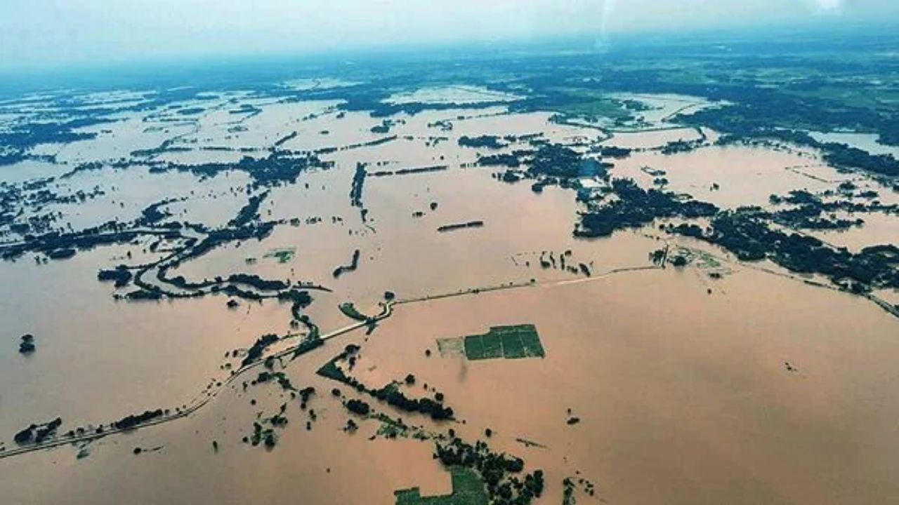
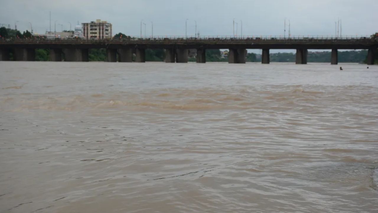
The most affected areas in Odisha are likely to include districts like Keonjhar, Mayurbhanj, Bargarh, Sambalpur, and Deogarh. These regions are under a red warning, which means extremely heavy rainfall is expected. In some places, the rainfall could exceed 21 cm, which can lead to flash flooding, especially in areas with poor drainage systems.
For the other districts, the IMD has issued an orange warning, meaning heavy to very heavy rainfall is anticipated. These include Angul, Dhenkanal, Sundargarh, Balasore, Bhadrak, and Jajpur.

What Can You Do to Stay Safe?
When facing such severe weather conditions, it’s crucial to stay informed and take proactive measures. Here’s how you can stay safe:
1. Stay Updated
Make sure you’re receiving accurate, real-time updates from reliable sources like the IMD, local news stations, and government advisories. You can always check the IMD’s official website for the latest information.
2. Avoid Waterlogged Areas
Flash floods can occur very quickly. Avoid traveling in areas that are prone to waterlogging, as even a small amount of rain can cause roads to become impassable.
3. Secure Outdoor Items
If you’re in an area likely to experience strong winds, be sure to secure outdoor furniture, garbage bins, and other lightweight objects that could become projectiles.
4. Follow Evacuation Orders
In extreme cases, if local authorities issue evacuation orders, it’s essential to follow them immediately. Flash floods and landslides can occur with little warning.
5. Avoid the Sea
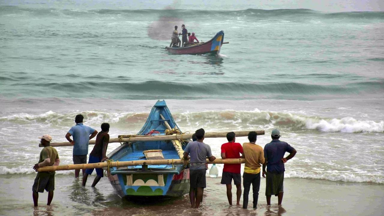
The IMD has also issued warnings to fishermen, advising them not to venture into the sea due to squally winds (ranging from 40-60 km/h) and rough sea conditions. The sea is expected to remain hazardous for the next five days.
6. Take Precautions at Home
- Ensure that your roof is secure and there are no leaks.
- Check gutters and drains to ensure they’re not clogged, as heavy rainfall can lead to localized flooding.
- Store emergency supplies, such as non-perishable food, water, medications, and flashlights, in case of power outages.
The Science Behind Heavy Rainfall
So why does the Bay of Bengal become such a focus for intense rainfall? It all comes down to climate patterns and ocean temperatures. When warm ocean waters meet the cooler air above, it causes water to evaporate into the atmosphere. This moisture-laden air rises, creating the low-pressure systems that feed rainfall. When this system becomes stronger, it’s more likely to cause prolonged and heavy rainfall, especially when it moves closer to land.
In addition, the monsoon season plays a significant role. The Bay of Bengal is a key player in the Indian monsoon system, which brings seasonal rains to much of India between June and September. These monsoon winds carry moisture from the ocean, and when they interact with landforms like the Eastern Ghats, they can release large amounts of rain.
How Can This Impact Daily Life?
The heavy rainfall expected in Odisha can have far-reaching effects. Here are some of the potential impacts:
1. Flooding: With intense rainfall comes the risk of flash floods, which can disrupt transportation, damage crops, and cause property damage.
2. Crop Damage: Odisha is an agrarian state, and farmers are likely to face losses due to the strong winds and heavy rains that can damage standing crops, especially in rural areas.
3. Transportation Disruptions: Roads may become impassable, and train or flight services might face delays due to the waterlogging and reduced visibility.
4. Health Concerns: Stagnant water can lead to the growth of waterborne diseases like cholera and dysentery, especially in areas where sanitation systems are affected.
Mayurbhanj Schools Stay Closed Today: Heavy Rainfall Warning Forces Immediate Closure!
Bridge Washed Away in Odisha’s Sunabeda Sanctuary Amid Torrential Rains; IMD Warns of More Downpours
Odisha Braces for Intense Rainfall: IMD Forecasts Low-Pressure System Impact
FAQs
1. How can I stay safe during a depression?
To stay safe, stay indoors when possible, avoid flooded areas, secure outdoor items, and follow official advisories. Keep an emergency kit with essentials like food, water, and medications.
2. Is it safe to travel during heavy rainfall?
No, it’s advised to avoid traveling during heavy rainfall or flash flood warnings. Roads can become impassable quickly, and the risk of accidents increases in low visibility and slippery conditions.
3. What should I do if I live in a flood-prone area?
If you live in a flood-prone area, ensure that your home is properly secured and that you have an emergency evacuation plan in place. Follow local government advice closely.
4. Can fishermen go out to sea during this depression?
No, the IMD has advised fishermen against venturing into the sea due to rough sea conditions and strong winds. It’s best to stay ashore until the conditions improve.
5. How does the IMD track these weather systems?
The IMD uses a combination of satellite imagery, weather radars, and advanced weather models to track the development of low-pressure systems and depressions. They issue warnings based on their predictions and observations.