The coastal state of Odisha is bracing for another round of intense rainfall as a fresh low-pressure system is expected to form over the Bay of Bengal. This meteorological development follows a recent spell of heavy downpours that has already impacted several districts. The India Meteorological Department (IMD) has issued warnings for widespread rain and thunderstorms, raising concerns about potential flooding and disruption to daily life.

Odisha’s Weather Update
| Key Fact | Detail/Statistic | Source |
| System Formation | A new low-pressure area is likely to form over the northwest and adjoining west-central Bay of Bengal. | India Meteorological Department (IMD) |
| Rainfall Forecast | Widespread light to moderate rainfall is expected, with isolated heavy to very heavy showers across Odisha. | IMD’s Regional Meteorological Centre, Bhubaneswar |
| Impacted Regions | Districts in northern and coastal Odisha, including Mayurbhanj, Keonjhar, Jajpur, and Cuttack, are on alert. | IMD Weather Warning Bulletins |
| Monsoon Status | Monsoon rainfall in India has been above normal so far, with several low-pressure systems forming. | IMD Director General, Mrutyunjay Mohapatra |
A New System Develops
A new low-pressure area is predicted to develop around August 25 over the northwest and adjoining west-central Bay of Bengal, according to the IMD’s latest forecast. This new system comes on the heels of a previous depression that brought significant rainfall to southern and western Odisha earlier in the week. The persistent formation of such systems is characteristic of an active monsoon season, which has been above normal for much of the country.
The formation of a low-pressure system is a key driver of monsoon rainfall. These systems are areas where atmospheric pressure is lower than the surrounding air. Warm, moist air rises from the sea surface, cools, and condenses, forming clouds and leading to heavy precipitation. When these systems move inland, they bring significant amounts of rainfall, often causing localized flooding.
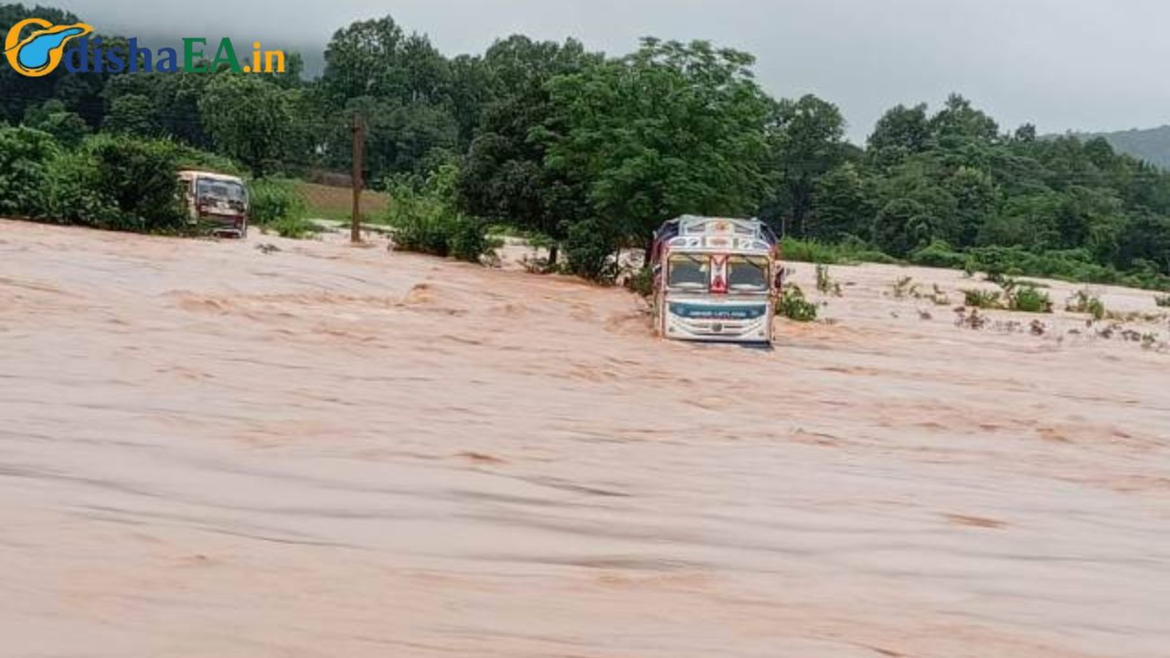
Forecast and Impact: Heavy Rain and Flood Concerns
The IMD has issued an “Orange Warning” for several districts, indicating a high probability of heavy to very heavy rainfall. Districts most likely to be affected by the new system include Balasore, Mayurbhanj, Keonjhar, and Jajpur in northern Odisha, as well as coastal districts like Puri, Jagatsinghpur, and Kendrapara. These regions are particularly vulnerable to flooding due to their proximity to rivers and the coast.
The anticipated heavy rainfall could lead to a variety of issues, including waterlogging in low-lying urban areas, disruption of traffic, and potential damage to “kutcha” (earthen) houses and roads. The advisory also warns of the possibility of landslides in hilly regions and advises against venturing into the sea due to rough conditions and high winds.
Government and Community Preparedness
In anticipation of the ongoing monsoon challenges, the Odisha government has taken proactive measures. The state’s Revenue and Disaster Management Minister, Suresh Pujari, recently met with Union Home Minister Amit Shah to request central financial assistance of ₹9,500 crore (approximately $1.15 billion) to bolster disaster preparedness. The proposal includes funding for 800 new multi-purpose cyclone and flood shelters and the development of disaster-resilient power infrastructure, which would involve underground cabling of power lines in vulnerable areas.
“Since power distribution networks are the worst hit during cyclones, shifting them underground will ensure faster recovery and uninterrupted supply to people during disasters,” Pujari told reporters. He added that the state has already repaired and readied its existing 1,000 cyclone shelters for emergencies.
Odisha’s Disaster Management Authority (OSDMA) and local urban bodies have also activated their urban flood and waterlogging management action plans. These plans involve round-the-clock control rooms, the engagement of local volunteers and women’s self-help groups, and inter-departmental coordination meetings to ensure a rapid response to any monsoon-related crises.
Broader Context of India’s Monsoon
The current weather pattern in Odisha is part of a larger trend across India. The Indian monsoon, which typically runs from June to September, has been particularly active this year. According to IMD Director General Mrutyunjay Mohapatra, the first half of the monsoon season saw the formation of six low-pressure systems, four of which intensified into depressions. This frequent system formation has contributed to a national rainfall surplus of 6% as of August 19.
However, the distribution of rainfall has been uneven. While many states, including Odisha, have experienced heavy rains, some regions have seen a decrease in rainfall, a pattern that is becoming more common. Research published in the journal Science Advances in 2021 highlights that climate change is making the Indian monsoon more “erratic,” with longer dry spells followed by intense downpours.
“The analysis reveals that both the heavy-to-extreme rainfall days and dry days are increasing, while the light-to-moderate rainfall days and wet days are decreasing,” according to a study on rainfall trends over Odisha. This trend suggests a move toward more extreme weather events, which poses a significant challenge for flood management and agriculture in the region.
Odisha Plans 800 New Shelters to Combat Cyclones and Floods, Centre’s Aid Requested
Odisha Hit Hard as Heavy Rains Pound State—Low-Pressure Turns Deadly Depression Overnight
Landslide Blocks Damanjodi–Narayanpatna Route in Koraput After Torrential Rain
End of Article
As the state prepares for the new low-pressure system, authorities are monitoring the situation closely. Residents have been advised to stay updated on the latest warnings, secure their property, and avoid low-lying areas. The effectiveness of Odisha’s comprehensive disaster management framework will be tested once again as it navigates this prolonged and intense wet spell. The forward-looking proposals to the central government underscore the long-term strategy to build resilience against the growing threat of climate-related weather extremes.